All Data for Green Deal (AD4GD) is a European project led by CREAF that will help to unify all Earth observation data in a single space and thus support priority actions of the European Green Deal. Just as a storage room can become an efficient warehouse if everything is sorted, labelled and accessible to everyone, this project aims to ensure that the future Common European Data Space will be an open, traceable and understandable information warehouse. Consequently, decision-makers will be able to consult them easily and undertake more effective policies on biodiversity, pollution and climate change.
In addition, the project, funded by the Horizon Europe programme, aims to enrich this common space with Earth observation data not only from traditional sources such as satellites or drones, but also from other emerging methods, such as citizen science, the Internet of Things or Artificial Intelligence.
This methodology will be tested on three specific environmental challenges in Europe: the health of urban lakes in Berlin, ecological connectivity in the Barcelona metropolitan area and air quality measurement with low-cost sensors.
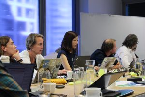
The 12 partners of the consortium that will execute AD4GD met in Barcelona for the first time last September. The project is coordinated by CREAF and has the collaboration of the Open Geospatial Consortium (OGC), research centres such as the European Centre for Medium-Range Weather Forecasts (ECMWF), the Fraunhofer-Gesellschaft FIT, the Kompetenzzentrum Wasser in Berlin (KWB), the Poznan Supercomputing and Networking Center (PSNC), the Internet of Things Lab (ITL), organisations such as the European Centre for Certification and Privacy (ECCP), companies such as ATOS and Design Terminal, the Mandat International foundation and Aston University (Birmingham).
A shared vocabulary
In order for everyone to understand and use the data collected when we measure the pulse of the planet, a common language must be created. This means establishing a universal vocabulary that is governed by shared norms, known as standards. This is why the AD4GD project will develop standards adapted to the new OGC APIbeing developed by the OGC.
This vocabulary is translated into practice in the form of metadata, those attributes that are associated with each piece of data collected and which contain valuable information. We are talking not only about the numerical values and their units but also about the type of variables they represent, the circumstances in which they were acquired, the instruments that were used and, most importantly, whether they can be compatible and combined with others taken by different groups under different conditions.
“Correctly labelling each piece of data and making these labels also speak a common language will be another challenge of AD4DG. That way unambiguous meanings are achieved, which allows stakeholders to exchange and use the available information”
Integrate the latest trends
The information coming from satellites is reasonably organised. After all, although its volume is enormous, the number of actors is not very large. On the other hand, European initiatives such as INSPIRE offer geospatial data in an open manner through international standard protocols. On the other hand, the consolidation of GPS, mobile phones and permanently connected low-cost sensors means that the number of new sources of field observations is enormous. This is why new methods of earth observation such as citizen science, the Internet of Things and Artificial Intelligence are increasingly making their voice heard in this field.
“While there are initiatives to structure observations in the field, the new trends are often not taken into account. This is why it is necessary to integrate all initiatives into a big data
space,” explains Masó.
High-level partners
CREAF is leading the financial and administrative aspects of the project while OGC coordinates the scientific and technical part. OGC, PSNC, ATOS, ITL and Aston University will collaborate closely in the standardisation and semantic interoperability development due to their experience in knowledge transfer and science-to-policy in other European projects.
AD4GD aims to integrate data from heterogeneous sources. CREAF provides its expertise with citizen science information at national and international level. The ECMWF participates in the satellite data integration with the help of ATOS, who will also lead the artificial intelligence data administration. IoT data will be handled by ITL and water-related information will be integrated by the KWB. The three pilot cases will be managed by CREAF (Barcelona Metropolitan area), ECWF (air quality in Europe) and KWB (urban lakes in Berlin) coordinated by Aston University.
Outreach of AD4GD results and international cooperation will be coordinated by MI with the support of ATOS and the ECCP, who will pay special attention to the ethics and data protection guidelines. Furthermore, the user-centred approach will be guaranteed by FIT due to their background in user interfaces and experience. Design terminal will carry the exploitation and sustainability related activities.
The creation of the Green Deal Data Space is done in collaboration with other projects and initiatives. Actually in the last EuroGEO workshop (novembers 2022) CREAF agreed to lead a new Action Group for the creation of the Green Deal Data Space that is initially composed of the following projects financed by EC: AD4GD, FAIRiCUBE, USAGE, B3, OEMC, EO4EU, EIFFEL-GEOSS and ILIAD; projects financed by other DG’s: GREAT and Data Spaces Support Center; and members of the European Commision.